New Storm Surge model launched

Posted on 28 January 2019
The SAWS recently released a new storm surge model operationally to help guide forecasters, parastatals and the public
When talking to a coastal manager, the term ‘storm surge’ will be well understood. For the rest of us, this term might seem familiar (well, at least the word "storm"). Storm surge is actually a coastal ocean phenomenon, where the usual (or expected) sea level is augmented due to ocean winds and atmospheric pressure.
The main concern of storm surge is coastal inundation and the fact that abnormally high sea levels extend the ‘reach’ of storm waves. According to recent research by the United Kingdom National Oceanography Centre, the ability to predict these events can save a country billions of Pounds as a result of coastal managers being enabled to respond to threats timeously. This helps protect coastal infrastructure and more importantly saves lives!
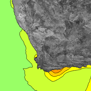
In response to this need, the South African Weather Service has just released its forecasting (or operational) storm surge model. This model will now provide the South African public with daily forecasts of this ocean phenomenon. Specialised products will also be provided to DM via the South African Weather Service forecasting team. SAWS forecasters will also provide expert interpretation of these forecasts to media and partner agencies.
The model output is currently available at an approximate 6 km resolution for the whole of the Southern African coastline. In the development of the model, the SAWS Marine team also managed to publish some scientific literature, establishing the novelty of the model. Ms T Williams, a scientist on the development team says: “It has been very exciting to be able to be part of a scientific development that you know will change South Africa for the better”. She goes on to say: “I look forward to seeing the impact of this product and to be part of the team taking South African coastal forecasting into the future”.